
Forests of the Red Duck: Canvasback's 250-Year Winter in San Pablo Bay

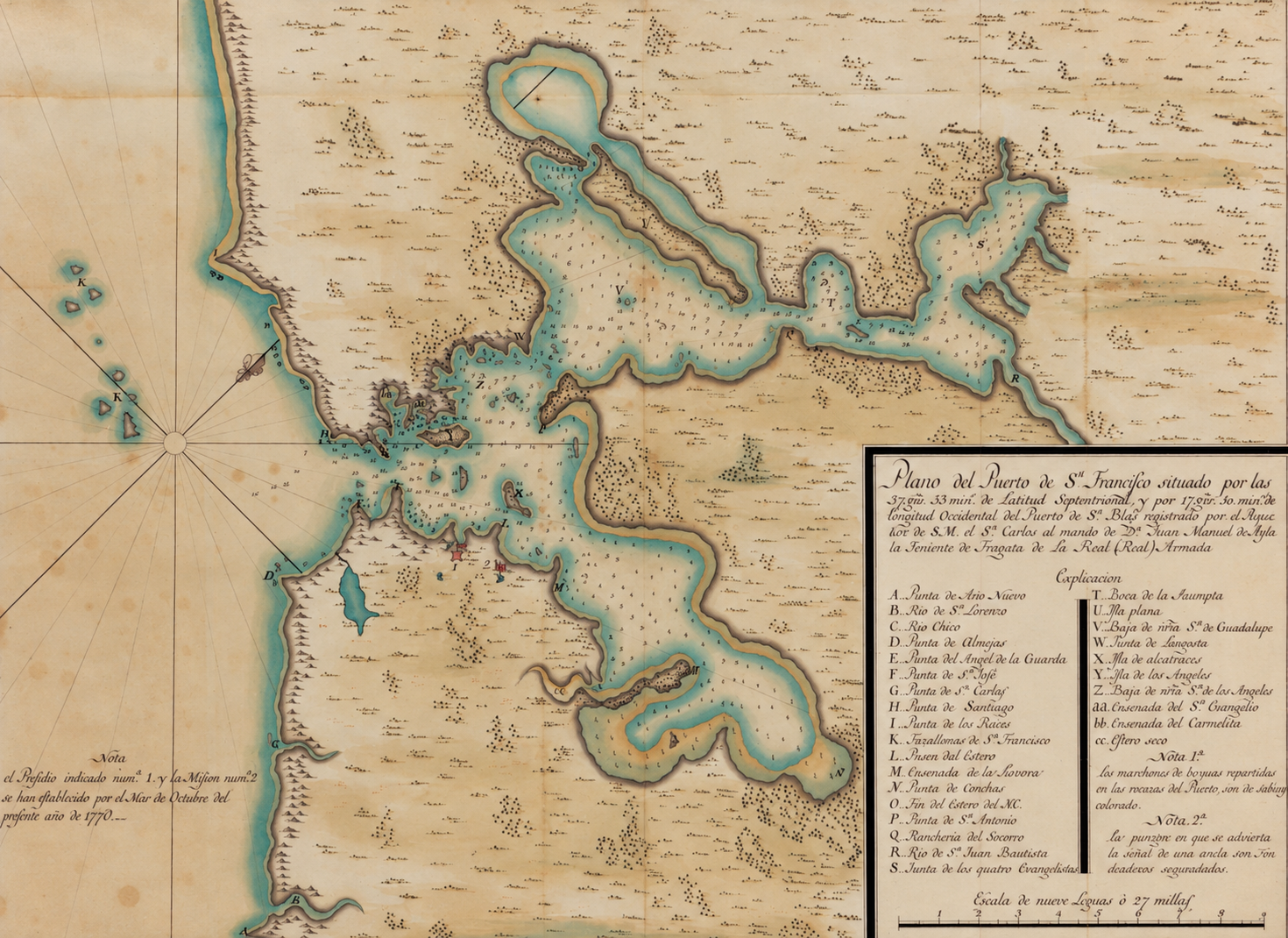
In the summer of 1775, a Spanish ship sailed into a bay no European vessel had ever entered. Its pilot, José de Cañizares, spent weeks sounding the shallows and sketching the shoreline. Along the northern edge of what we now call San Pablo Bay, he noted something that stopped him: the marshes were "forests of the red duck."
That red duck was the canvasback. Two and a half centuries later, it still comes back to the same water every winter, and it is arriving right now. This is the story of the bird, the map, and why the marshes we paddle at the mouth of the Napa River have mattered to both for so long.
The first map of the Bay
On August 5, 1775, the packet ship San Carlos, commanded by Lt. Juan Manuel de Ayala, became the first ship to sail through the Golden Gate. The crew stayed until mid-September, and Cañizares, the ship's first pilot, used that time to survey the whole estuary, from the Golden Gate up past Mare Island toward the Carquinez Strait.
His 1775 chart, the Plano del Puerto de San Francisco, is one of the very first maps of San Francisco Bay. He came back the following year and drew a more finished watercolor version, which now sits in UC Berkeley's Bancroft Library as one of its great treasures. He drew that 1776 chart the same summer San Francisco was founded, while the American colonies were declaring independence on the other side of the continent.
[MAP IMAGE HERE: Cañizares, Plano del Puerto de San Francisco, 1775. Courtesy UC Berkeley Library.]
Look at the north shore on the map and you're looking at the Carneros marshes, Sonoma Creek, the Petaluma River mouth and Mare Island before levees, salt ponds or Highway 37. Most of those tidal marshes, roughly 85 percent, have since been diked, drained or altered. What Cañizares saw was a vast, unbroken wetland, and it was full of ducks.
Meet the canvasback
The canvasback (Aythya valisineria) is one of North America's largest ducks and one of its fastest fliers. Males are easy to pick out: a chestnut-red head, a pale back the color of old canvas, and red eyes. Females wear softer browns and grays. Both sexes share the bird's signature profile, a long black bill that slopes straight up into the forehead with no dip.
Canvasbacks are diving ducks. Rather than tipping up like a mallard, they disappear completely, feeding on plant roots, tubers and small clams on the bottom. Their scientific name nods to wild celery (Vallisneria), a favorite food.
They breed far away, in the prairie potholes of the northern plains and up into Alaska and the Arctic, and fly south to spend roughly November through February on open, shallow water. For a big share of the West Coast population, that water is San Pablo Bay.
Why our corner of the Bay matters
San Pablo Bay supports the largest wintering population of canvasbacks on the West Coast. The continental population has hovered around 580,000 birds for decades, about a quarter of them in the Pacific Flyway, and the San Francisco Bay estuary has historically held more of them than anywhere else in the flyway. More than half of the estuary's canvasbacks were traditionally counted in the North Bay.
The bird is part of why this shoreline is protected today. A steep drop in canvasback numbers in the 1960s helped spur the creation of the San Pablo Bay National Wildlife Refuge, which now stretches along the north shore from the Petaluma River to Mare Island. Next door, the Napa-Sonoma Marshes Wildlife Area covers about 15,200 acres of tidal sloughs and baylands between the Napa River and Sonoma Creek, much of it being restored from old salt ponds.
The news isn't all good. Bay Area canvasback numbers have been sliding for decades, with more birds shifting to ponds in the San Joaquin Valley. The huge rafts Cañizares saw are gone, but plenty of canvasbacks still winter here, and every restored acre of tidal marsh gives them more of what they came for in 1775.
When to see them from the water
The best window is November through January, when diving ducks and shorebirds hit peak numbers in the bay's wetlands. Look for canvasbacks alongside scaup, bufflehead, goldeneyes, ruddy ducks and scoters, with willets, godwits, curlews and dowitchers working the mudflats at low tide.
A kayak is one of the best ways to see them. You sit low and quiet, and the birds tolerate a slow-moving boat far better than a person walking the levee. A few habits help:
- Give rafts of ducks plenty of room. If they start swimming away or lifting their heads, you're too close.
- Never paddle toward a flock to flush it. Winter is about saving energy, and every forced flight costs them.
- Bring binoculars. A canvasback at 100 yards is still unmistakable once you know that sloping profile.
- Check the tides. Falling and low water pulls shorebirds onto the flats.
One heads-up: waterfowl hunting runs October through January in parts of the Napa-Sonoma Marshes. Our guides know where and when to paddle.
Celebrate it at the Flyway Festival
Every February, birders flock to Mare Island for the San Francisco Bay Flyway Festival, timed for the peak of winter migration. The three-day event celebrates more than a million shorebirds and hundreds of thousands of ducks, geese and hawks that pass through or winter around the Bay. Expect guided walks, a wildlife and birding expo, live birds, art, and tours of historic Mare Island. Most of it is free.
The canvasback is right at home here. The festival's co-founder has noted that Mare Island and the adjacent Napa River are the winter home of about 70 percent of the canvasbacks on the Pacific Flyway.
The setting has its own deep history. Mare Island became the Navy's first shipyard on the Pacific in 1854. The festival was born in 1996, just months after the shipyard closed, partly to help Vallejo find a new identity. The city itself is named for General Mariano Guadalupe Vallejo, the Californio commander who oversaw the North Bay frontier under Mexican rule. Founded on his Rancho Suscol, Vallejo even served as California's state capital in 1852–53.
February 2027 should bring the 32nd festival. [ADD 2027 DATES]
Then come the swallows
Just as the canvasbacks start heading north, another long-distance traveler returns: the cliff swallow. These are the same species made famous at Mission San Juan Capistrano, where by tradition the swallows return every March 19, St. Joseph's Day, and leave again on October 23.
The journey behind that legend is real. Cliff swallows winter in South America, as far south as Argentina, and fly thousands of miles north each spring. The birds don't arrive on a single day, but they do reliably show up in Southern California around the spring equinox.
The flight continues north, and the swallows soon reach the Napa Valley. Watch for them swooping low over the Napa River for insects and building their gourd-shaped mud nests under bridges and eaves. Paddling under one of those colonies in spring, with dozens of birds wheeling overhead, is hard to beat.
Paddle the season with us
From canvasbacks in the depths of winter to swallows in early spring, the Carneros Estuary tells the story of the Pacific Flyway one season at a time. Join us on the water and look out over the same marshes Cañizares mapped 250 years ago. BOOK A TOUR
Sources
- Bay Nature: Canvasback
- UC Berkeley Library: Plano del puerto de Sn. Francisco (1776)
- Bancroft Library: Visualizing Place
- California Magazine: Collections, Summer 2026
- Friends of San Pablo Bay NWR: Habitat for the Canvasback
- USFWS: San Pablo Bay NWR
- USFWS: San Pablo Bay NWR recreation
- CDFW: Napa-Sonoma Marshes Wildlife Area
- Wikipedia: San Carlos (1767 ship)
- Bay Crossings: A Migration Celebration Takes Wings
- Friends of San Pablo Bay NWR: Flyway Festival
- Wikipedia: Vallejo, California
- Audubon: Swallows of Mission San Juan Capistrano
- BirdNote: The Swallows of Capistrano